Biography of a C-4 Stereoplanigraph *
(Note, the Mount Diablo Surveyors Historical Society now owns this
instrument)
C. M. COTTRELL
and MILTON GLICKEN,
Fairchild Aerial
Surveys, †
Abstract: In 1934
a C-4 Stereoplanigraph was imported into the United States by Fairchild Aerial
Surveys. Until 1945 it was the only Universal Plotter in the country and is
still the only C-4. Despite rapid technological advances in mapping, the
instrument is still earning money for its original owners. The history of this
unique instrument is the subject of this paper.
This is not a
very technical paper, Rather, it is the history of a particular stereo plotting
instrument-how it was developed, how it performed some assignments that could
not otherwise be performed, and what its recent history has been. Nor is this
an obituary, for the instrument is still going strongly,
The beginnings go back to the late 1920's, when the C-3 was the current
model of the Carl Zeiss Company, in Jena, Germany. Improvements and changes in
the C-3 became obviously necessary as the technology advanced. A Mr. Gulbranson
was the chief designer, when the C-4 stereoplanigraph was finally announced by
Zeiss in July of 1930. It was a fine instrument, not only by 1930 standards,
but even by 1960 standards, as we shall presently see.
In the years 1931 to 1937-a total of 20 C-4 stereoplanigraphs had been
constructed but only one came to the United States during that period. That one
is the subject of this paper. The others went to places like Mukden, Nanking,
Berlin, Delft, Moscow, Madrid and Oslo--all in countries, which suffered
considerable destruction in wars between then and now. Whether any of these
C-4's survived is not known, but it is interesting to contemplate that the one
which came to the United t States also played an important part in some of that
warfare.
But that is getting ahead of the story. In 1931, when Fairchild Aerial
Surveys placed its order for the C-4 the instrument wasn't considered a weapon
of war. In fact previously the U. S. Army wouldn't consider it at all for any
purpose; topographic mapping by aerial methods was not accepted technique by
any U. S. Government agency. But Leon T. Eliel of Fairchild had made a trip to
Europe in 1930 and was convinced not only that mapping by aerial means was
going to be the only technique of the future but that the recently announced
C-4, was the instrument to use. The, problem, however, was to convince the
mapping agencies of the U.S. that topographic work could be done by
stereoplotting equipment in general and by the C-4 in particular, faster and
cheaper than by methods currently in use.
At the same time, Fairchild had purchased a four-couple camera from
Zeiss with the object of using its pictures in the C-4, which was designed for
it. Eliel then proposed that, if the Air Corps took the pictures of a suitable
test area with the four-couple camera and if the U.S.G.S. provided the control,
the maps would be drawn at Jena by the Zeiss experts and the Government could
compare it with existing unpublished information. The area selected was the
Bushkill Quadrangle in eastern Pennsylvania.
But big projects like this never work out as planned. The Air Corps took
the pictures, but there weren't many Government dollars available for ground
control in the long, hard winter of 1932-33. When the control was finally
obtained in the late summer of '33, it was shipped to Jena, But there was
another last-minute change. It was decided to ship the instrument and the data
to the United States and do the work in this country instead of Jena. The
plotter arrived in Washington in May of 1934 and was assembled in space donated
by the Interior Department.
Dr. Heinz Gruner, well known in the
Society, was given a leave of absence from his civilian job at Wright Field,
and came to Washington to help draw the Bushkill Quadrangle (he had, in fact,
taken the photography also). He was assisted by Russell K. Bean and Leon T.
Eliel, and later by C. M. Cottrell, the senior author of this paper.
One evening during that summer, Bean, Cottrell and Eliel quit work early
and visited at the home of Captain Scott Reading. It was there and then that
the American Society of Photogrammetry was born.
The Air Corps report on the Bushkill
Quadrangle appeared in 1935, four leisurely years after the conception of the
project. But it was to be many years more before the Federal Government
acquired a stereoplanigraph despite the favorable tone of the report. This was
not due to resistance to progress, however. There were other factors involved
but the fact remains that it was ten years before a stereoplanigraph was used
by the Government.
The C-4 did another small topo job at Mexican Springs, New Mexico, that
summer of 1934 before it was dismantled and shipped from Washington to Los
Angeles.
Before long it had another assignment-- Boulder Dam in Black Canyon (now
called Hoover Dam) had been completed and water was beginning to back up into the
newly created Lake Mead. Someone suddenly realized that maps were immediately
needed of the bottom of the new lake for use in subsequent studies of silting
and reservoir capacity.
Fairchild flew the area with the four-couple camera and immediately began
establishing control starting at the upstream face of the dam. Luckily, Black
Canyon was deep and narrow at that point, so the water hadn't covered too much
area as yet; by hard and fast work the control crews managed to keep ahead of
the rising water; and they obtained the necessary control. Any means of mapping
other than the C-4 and four-couple camera would have created a requirement for
more control than could possibly have been obtained in time.
The map was checked by low-altitude single-lens photos of the shoreline
at 20-foot elevations of the reservoir. A special plane and crew were held in
Las Vegas for this purpose and they took off whenever the gauging station
recorded an additional 19.95 feet of water, to take new photos, which were compared
with the contour map. This was perhaps the most rigorous and the most graphic
check of contouring ever devised. It could also be called the most
uncontestable and final check, for there could be no rebuttal to it.
In spite of this project and similar triumphs, aerial mapping caught on
slowly in those years. Though the C-4 was kept moderately busy in the years
1935-1939 doing mapping for the TVA and the Army Corps of Engineers, there was
no move by anybody to import a similar unit into the United States. Thus it
happened that when the increasing pressure of the defense program began to be
felt, the C-4 began to receive a good deal of that pressure.
In the spring of 1940, an order was received for a cantonment area near
San Luis Obispo, California. Specifications and instructions were received by
Fairchild in Denver one day; the next day the photography was taken and on the
following day the control party left for the site. An assistant went along to
do the computing on the spot and as soon as enough control has been assembled
it was rushed back to Los Angeles for starting the drawing. And that's pretty
much typical of what happened in the next five years. Every- thing in a hurry,
and understandably so, for this was the only means in the U. S. of turning out
topo work with a combination of speed, efficiency and economy of scarce
manpower.
The conversion to single-lens photography took place in 1942. Two
aircraft were to fly some quadrangles in eastern Pennsylvania. They picked up
three K-17 cameras at the Long Island plant of Fairchild Camera, flew to
Pennsylvania to take the photography and then took the cameras to Rochester.
There the lenses were taken from two of the cameras, placed by Bausch &
Lomb in special lens barrels and shipped to Los Angeles. They were installed in
the C-4 along with a special projection lens that had been designed there, and,
in a week's time the instrument had been converted for use with 6-inch 9 X9
metrogon photography.
In a certain sense, the C-4 was thus converted to the American type of
mapping photography, which with some refinements but no major change of focal
length or format, is still in use. This change stood the instrument in good
stead, as the ubiquitous K-17 camera was distributed through all the Army Air
Force mapping and reconnaissance aircraft, and even through the R.A.F.
As the war progressed and the C-4 in Los Angeles was the sole source of
quick maps from tri-metrogon photography, assignments came to it from
everywhere. First cantonment areas, then training camps, then Southern France,
then Central France, then the South Pacific, then Japan. In all, 244
quadrangles were drawn, mostly at 1:37,500 with 10-meter contours, and much of
it from tri-metrogon photography. Though a number of other agencies were
turning out quadrangles too, the C-4 was the tool chosen when time was tight. A
set of photographs of Borneo, for example, was rushed to Los Angeles and in
three weeks eighteen quadrangles were delivered to the lithographers for
reproduction; a week later a special Navy transport plane was standing by to
fly the maps to the South Pacific. Therein lay one of the real advantages of
the C-4 for it was the only drawing instrument that could use tri-metrogon
photography, without prior rectification; when time was of the essence, this
was of crucial importance.
At this point it would be romantic to say that the C-4, sitting
impressively in its darkened room, took on an awesome personality of its own,
as it quietly but efficiently consumed operators as well as diapositives,
working around the clock for years at a time to win single-handedly a war
against its own creators. Its operators gave it some nicknames in keeping with
their half-serious awe of this center of their lives. But, although it may some
day appear that way in a popular magazine article, the truth is merely that the
instrument, with routine maintenance, continued to operate well and that the
operators thought no more of it than a stenographer does of her typewriter.
After World War II Government orders fell off, but the dammed-up
commercial demand took up the slack and the instrument was kept busy
continuously for a number of years. There was no longer the monopoly that had
previously existed, of course, Wild instruments and other stereoplanigraphs had
been imported into the United States, and the Kelsh Plotter, -- capable of
doing many of the things previously reserved for universal instruments-appeared
on the market. But the C-4 was still irreplaceable for bridging and other
chores and remained in very active service until 1953.
In that year Fairchild bought the first of its two C-8's to supplement
the A-5 it already had. The C-4 then became obsolescent. It was limited to
metrogon lenses, whose use was becoming less and less frequent in mapping
photography, and setting up a model took much longer than on the new C-8's. So
the C-4 became something of a museum piece whose cover was lifted only to show
it to a visitor. But the Fairchild management was reluctant to sell or scrap
the instrument. After all, its optics were still sharp and the mechanical parts
in excellent working condition-it was simply that there were more efficient
ways of doing the same thing.
Then, in 1962, the picture changed again, with a new lens system to
handle planigon photography, the C-4 could draw contours on models with too
much relief for a Kelsh. Also in certain economically marginal conditions,
considering that it is completely amortized, the C-4 might do some bridging. So
the new lenses were ordered and the instrument was brought out of retirement.
Today the C-4, designed in 1927-1929 and
manufactured in 1931-33, is still efficient and accurate enough to be making
money for a commercial firm in a highly competitive industry. The first and
still the only one of its kind in the U. S., its very existence as a productive
instrument in 1963 is a tribute to the ingenuity of its designer, the skill of
its fabricators, the foresight of its importers and the business abilities of
its owners. It appears to have many constructive years ahead of it, as any
30-year old should, and another chapter may some day have to be written to this
biography before the instrument's life span is completed.
* Presented at March
24-30, 1963 ASP-ACSM Convention, Hotel Shoreham, Washington. D. C.
† 224 East 11th St., Los
Angeles 15, Calif.
This paper was copied
from Photogrammetric Engineering, Published by the American Society of
Photogrammetry, Vol. XXIX, No. 4, pp 689-691, July 1963
Paper republished by the
Mount Diablo Surveyors Historical Society, November 30, 2007, all rights
reserved.
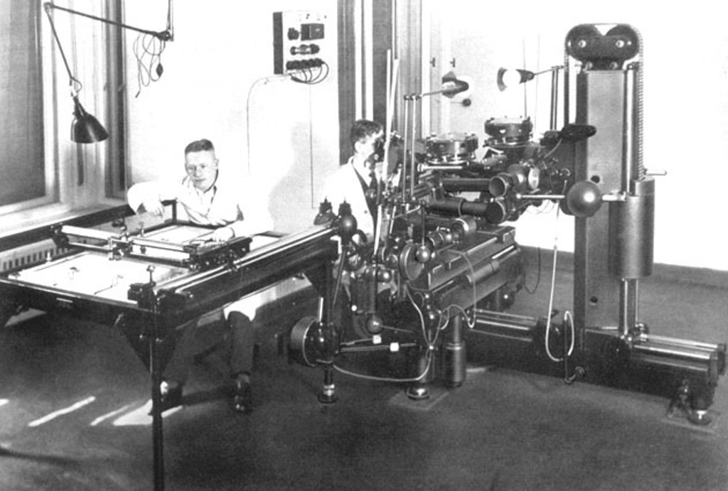
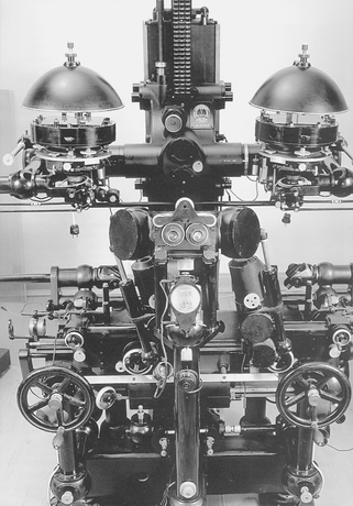
To view photographs of a C-4, (but not the one the subject of this paper) click here Photo 1
Photo 2
MDSHS is a California non-profit public benefit
corporation organized under
IRS 501(c)3 (Federal #8916806802, CA 1835904).
Website designed and maintained by Michael J. Foley, PLS.
Copyright © 2007, 2008 MDSHS.